Notes from Community Meeting - Subdivision Discussion
About 50 residents attended a meeting last night to discuss the three-stage development proposal to subdivide a large block (approx 70 hectares) at Sisters Beach into 72 lots.
The land to be subdivided spans nearly 70 hectares (almost all of the green paddock area in this photo)
Residents were informed that:
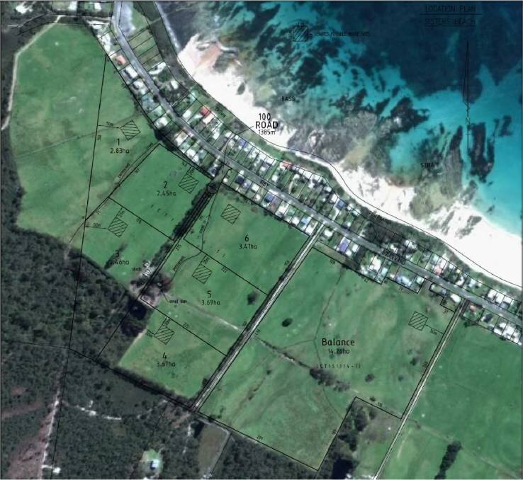
Stage 1 (6 residential blocks) has already passed council and blocks were already selling
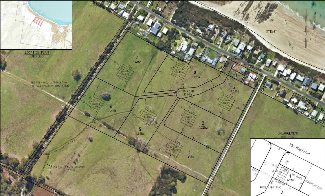
Stage 2 (8 residential blocks) has already been advertised by council and that the time to make representations has passed, and that this is likely to go to the next Council meeting for a decision on Tuesday 28th January.
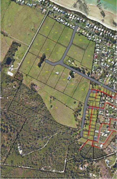
Stage 3 (58 residential blocks) was now advertised and that residents could make representations by COB on Tuesday 28th January. Download Planning Application SD2085
Opening Discussion
people were upset that the community were only made aware of this large project via a council development application and were concerned that there was no community consultation
people said that this development would have a major impact on their town and would like an extension to be able to fully understand its implications
discussed the planning process and how the system works
People said that they have found it difficult to understand the planning scheme and process. They asked to speak with council as a group (but were informed that it was too late now that this application was with the planning authority).
It was therefore suggested that we get some professional planning advice.
This was agreed to (people agreed to pass hat around).
It was suggested that those who wish to make a representation to council wait until this advice is received (see below added 23 Jan 2020).
Please find a link below with comments to assist in making a representation to the application currently on public display at Waratah-Wynyard Council for a 58 Lot subdivision at Bridge Street, Sisters Beach. It was advised that people write their own representations (speaking about the issues you raised at the meeting, and include some reference to these comments).
For those that said they’d like to contribute to the cost of the planning advice - $10 each should cover it (once we reach $300 this note will be taken down). Bank details below. Please then email sistersbeachnews@gmail.com to say that you’ve paid.
Account Name: Sisters Beach Community Association
BSB: 037-620
Account: 111376
Ref: Planning
Concerns raised at this meeting
Impacts on the town and the environment (land and sea)
Traffic impacts on Irby Circus and Irby Blvd and single bridge to get out
Privileged to live in National Park - the subdivision (in its current format) goes against many of these community values
iCEP - will Council look at the feedback given and consider this in the application?
Onsite water disposal (water run off from larger blocks, lack of infrastructure, implications for Irby Blvd and the ocean + potential Environmental Health Hazard)
Sewerage (for the low density lots, does the current system have capacity for extra load?)
Native flora and fauna (there is no assessment in the application but there are many threatened species in the area)
Clearing of vegetation (there are contradictions in the application regarding the clearing of land - difficult to understand)
Traffic impact (there is no traffic impact assessment in the application)
Bushfire risk (single road entry into Sisters Beach, people are worried)
Development not keeping with the area
Electricity supply (this application has asked for above ground power)
- above ground power is a fire hazard (lightning strikes)
- planning scheme states that above ground power must be without visual intrusion (have they considered the visual amenity of the National Park from Irby Blvd residents?)Dwelling density is not keeping with the local area
Mallacoota – could this happen to us? Population increase = danger increases.
Public Open Space - could council enforce a contribution?
Other comments from meeting attendees post meeting
The area is habitat for a number of listed threatened species including federally listed EPBC species including; Wedge Tailed eagle, White tailed sea eagle, Tasmanian Devil, Spotted Tail Quoll, Eastern Barred Bandicoot (particularly relevant given the area to be developed is grassland). In terms of flora species there is Bansksia Serrata and potentially a unique species of Xanthorea (grass tree) and potentially other species - Accordingly we would expect a more comprehensive site assessment for threatened species, especially noting there are eagle nests identified in the proximity.
The development site regularly floods in winter with large areas of surface water visibly draining across the sites. This raises concern regarding the impact of additional hard pans/surfaces, driveways and culverts associated with the development and the ability of existing drains and infrastructure to cope with higher flows which does not appear to be addressed in the application.
Noting that the development and improvements to drainage are likely to modify groundwater has the site been adequately assessed for potential acid sulphate soils which occur in the NW coastal environs: this has potential to affect the lifespan of current and future infrastructure and does not appear to have been addressed in the application.
The volume of new dwellings and potential increase in stormwater has raised the issue of capacity at the current sewage treatment works. Is there capacity for this number of dwellings and additional load? is any such increase likely to impact treatment (primary, secondary etc) and subsequent discharge in high flow events? What impact will any additional load have on discharge quality and will this impact water quality on the beaches and at the effluent discharge point in the ocean - noting some of the unique marine species in the immediate area; Rocky Cape is now a key sentinel point for study of marine species migration due to climate change and a key stopping point on the migration of listed whale species.
Noting the importance and prevalence of Aboriginal Cultural Heritage in this area have appropriate Cultural Heritage Assessments been undertaken for the proposed development site?
The development application appears to assume the visual amenity in relation to utilities and associated infrastructure primarily applies to the seascape, when the fact is current residents value the visual amenity of the National Park and bush as equal, if not greater value and this should be considered in the development assessment.